First off, I have to say this will be an awesome feature to have. However, I am having trouble getting it to work. Everytime I click the "Create Radio LOS Viewshed" or "Create Optical LOS Viewshed" I get the following error and I have tried all sorts of different settings on the Viewshed Configuration. Is there a user guide available?
I'm able to create viewsheds using the site in the project file without any problems. I do see the same error when I have network connection issues. Try the network tests:
- Tools -> Options -> Path Profile -> Test profile service
Both of these must be successful for the viewsheds to work.
The online map uses an embedded IE frame, so make sure that you don't have any software (such as antivirus software, plug-ins, etc) which is injecting content into the viewshed response. You should also be running the latest version of IE and LINKPlanner.
Sorry to drag this back up, but it’s not working again. Ran the network and profile tests. Everything tests good. Getting the below error. Reduced the range to 1 mile, even tried taking your zip file from June and running it, and I get the same error. Thoughts?
I can see your latest requests, from 25 minutes ago, in the server log. I’ve tried running the same requests and they take a few seconds to calculate, as expected, but the results come through fine. This is one of the results…
If you have local network connection issues whilst the client is polling the server, waiting for the results, then it will show an error similar to the one above.
There is no evidence of an error on the server, so I’m assuming that it was a connection issue somewhere. Try a different connection if you can to see if that is more stable.
Looks like you are correct. There must be something blocking in our company firewall. Can you provide me with application/port info I should be looking for on our firewall?
Regarding “Optical LOS Viewshed”
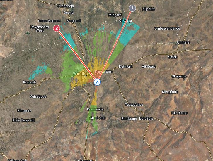
I would like to request if we can improve the current limitation from 30Km to 100Km.
I used UBNT to assist with this as i hoped Cambium would improve this feature in time but found they still haven’t improved on it.
This is a great feature helping to plan new locations for Towers to expand the network reach.
I don’t usually comment on other planning tools, but since you raised it… The last time I looked, the UBNT planner uses a fixed resolution, for instance, always 300 pixels radius (I don’t know the exact figure). This means that there is no real time/complexity cost to increasing the radius, the image just loses clarity as each pixel covers a larger area. You can see the coverage change at a given location as you increase the radius. We always use the resolution of the underlying data - so 30 m resolution for most of the world (UBNT only use 30 m data for the US).
At 30 km, the resulting viewshed image contains roughly 785,398 pixels. At 100 km it would be around 8,726,646 pixels. This would take minutes to calculate using the current code and the resulting image would be too large to display in the embedded IE browser without additional tiling (the old version of IE running the map has size restrictions on the image layer).
Most people planning PMP networks operate at much shorter ranges than 30 km so the current limit isn’t a factor. Are you using it to plan your PTP network or your PMP network?
I’m not saying that we will never increase the limit, but it is a non-trivial task and it isn’t currently a priority for us. If more people start asking for it then it will help to increase the priority.
Yes i do use the Tools for PMP.
But i also Build an entire route with only PTP.(Example building my very own wireless pipeline from one town to the other or hard to reach clients in distant isolated locations) This involves initial low capacity network “Faster delivery time” Longer links between 45Km to 60Km and sofar only required to built x2 links around 150km range.And the ability to identify Low and high ground from using your planning tool plus working out obstruction has greatly enhanced my skill levels over the years
Im operating in Africa were i have a fast terrain to cover and need to plan were i would plant a repeater/hop.
Then as the capacity demand increase we shorten the links and also at the same time branch out from those hops.
Hope this helps give you an idea why im making this request.
Either way im still very happy with Cambium Link planner and is still one of my essential tools.