With Release 2.4.2 users now have the ability to do a patch analysis to programmatically determine if a location is covered.
It allows a user to define a patch area (a location with a radius). On the backend a virtual heatmap is generated for each site/radio within range. The patch is parsed, and metrics about coverage are returned.
Example payload:
{
  "lat": 35.039577,
  "lon": -97.949822,
  "patch_radius(m)": 20,
  "max_distance(m)": 13000,
  "prop_mode": "nlos",
  "signal_cutoff(dBm)": -72,
  "height_above_clutter(m)": 4,
  "height_above_ground(m)": 10,
  "report_signal_percentile(pct)": 75,
  "radiolist": [
    "df461b62-aa55-4769-284a-2acd61abffa1",
    "8cb4ed9b-8d59-f140-7de0-aebbcfb3afa3"
  ]
}
In this example cnHeat generates a 20m radius area around lat/lon (35.039577,-97.949822). Customer installation height is 4m above rooftop and 10m above ground.
Only two radios are considered. Eliminating the “radiolist” section will default to processing all radios within the defined 13000m range from the provided lat/lon. Radios faced away from the customer (+/- 15 degrees of the beamwidth of the sector) are filtered out.
Only pixels with a signal of at least -72dBm are considered. These signal levels are sorted. The 75th percent strongest signal strength on the list is returned in results. (That is, the strongest 25% signal strength is discarded to provide a more realistic overall signal level.)
Users can define LOS analysis only with a prop_mode value of “los” or use a “nlos” value to analyze both los+nlos.
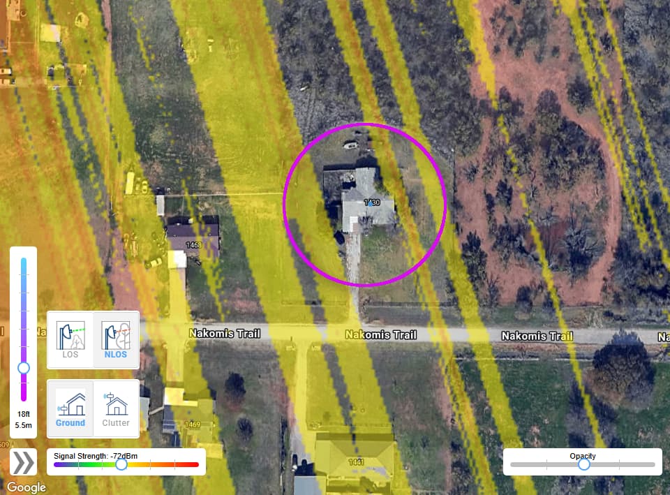
Although the heatmaps generated are virtual (on the backend only and not visible to users), here is a visual example of why this type of lookup is important. The user may only have a single location in the center of the roof. Checking just that location ignores the fact that coverage may be accessible at corners of the roof or even somewhere in the yard. This feature gives more flexibility for operators.
This endpoint allows users to define a “height above ground” and a “height above clutter”. This allows users to define installation heights that are different when above ground vs above a rooftop. (e.g. The operator is willing to put a 10ft pole somewhere in the yard and is willing to use a 2ft J-mount on the roof.)
Note: When “above clutter” falls on a tree then the results are discarded so that only rooftops are considered for the “height above clutter” portion of the analysis.
Note: Each cnHeat project is allocated 100 free credits for month for doing the patch_analysis. Additional credits can be purchased with part number HT-SUB-API-5K. ($250 for 5000 queries) These purchased credits do not expire. They roll over month to month and are only used after the free credits are exhausted.